Unseasonal Spring Snow Blankets Australia’s Southeast Before Bureau Predicts Sudden Warmth and Storms


A dramatic and unseasonal polar blast swept across southeastern Australia over the weekend, coating major alpine resorts and elevated regions in thick layers of November snow. The sudden wintery snap caught residents, tourists, and meteorologists by surprise, transforming landscapes in New South Wales, Victoria, and Tasmania into scenes more reminiscent of mid-winter than late spring. However, according to the Bureau of Meteorology (BoM), the icy interlude will be short-lived, with temperatures poised to rebound sharply as a traditional springtime storm pattern sets in across the eastern seaboard.
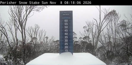
The weekend weather event brought tangible disruptions and striking visual contrasts across multiple states. Major alpine tourism hubs, including Thredbo and Perisher in the Snowy Mountains of New South Wales, alongside Mount Hotham in Victoria, recorded notable snow accumulations throughout Saturday and Sunday. Further south, the iconic peak of Kunanyi/Mount Wellington, overlooking the Tasmanian capital of Hobart, was similarly dusted with a layer of white. Down at lower elevations, the severity of the weather manifested differently; images circulated widely of the Kingston Beach Oval in Tasmania completely blanketed in heavy layers of hailstones following a severe localized storm on Saturday afternoon.

While experiencing snow in November is uncommon, weather historians and meteorologists note that it is not entirely unprecedented. Many of the exact regions impacted by this weekend’s cold snap recorded similar, albeit brief, snowfalls during late spring in November 2022. Nonetheless, the timing of the system prompted an immediate wave of commentary and footage across social media platforms. Madeleine McVie, a retail manager stationed at Thredbo, captured the astonishment of many locals when she posted updates online on Saturday afternoon. Expressing disbelief at the conditions, McVie shared videos of herself navigating completely empty chairlifts through a persistent, heavy snowfall—a stark departure from the typical outdoor activities associated with the Australian warm season.
Behind the sudden drop in temperatures was an intense weather system funneling a mass of cold air directly northward from the Antarctic region. The Bureau of Meteorology explained that strong, biting south-westerly winds accompanied the system, drastically lowering apparent or "feels like" temperatures well below the actual maximum forecasts. By midday on Sunday, major urban centers including Adelaide, Melbourne, Hobart, Canberra, and Sydney were experiencing conditions that felt significantly colder than 13 degrees Celsius. This shivering reality stood in sharp contrast to northern and western parts of the country, where cities like Brisbane, Perth, and Darwin enjoyed mild, warm weekend conditions well into the twenties and thirties.
The transition out of this unseasonal cold snap is expected to be swift and pronounced. Tristan Sumarna, a meteorologist at the BoM, indicated in an interview with ABC Radio Sydney that the lower temperatures will begin to dissipate rapidly starting Tuesday. As the southerly airflow weakens, a warmer air mass will move across the region, pushing temperatures in parts of Sydney into the mid-twenties and potentially reaching the low thirties by the conclusion of the week. Sumarna noted that this rapid warming trend will pave the way for a classic "storm-like pattern," which is characteristic of dynamic springtime transitions in New South Wales. Meanwhile, fine weather is anticipated to return to Tasmania and Victoria early in the week, with Melbourne predicted to reach the low twenties by Monday lunchtime, and Hobart anticipating a maximum top of 19 degrees Celsius.
Climate Context and Broader Meteorological Implications
While localized spring snow events occasionally occur, this weekend’s weather phenomenon unfolds against a backdrop of mounting concern regarding long-term climate disruption and shifting seasonal baselines. Meteorological authorities, including the Bureau of Meteorology and various international bodies such as the United Nations, have issued repeated warnings regarding the emergence of a powerful, supercharged El Niño cycle. This major climate driver is projected to exert profound influences on global weather patterns, heightening temperatures and altering precipitation norms across both hemispheres.
The current system may well represent one of the final significant cold snaps of the year for Australia’s southeast. Scientific consensus points toward a predominantly hotter and drier southern hemisphere summer driven by the prevailing El Niño conditions. This macro-climatic shift carries severe implications for the region, most notably an elevated risk of prolonged droughts and heightened bushfire danger across Australia and southern Africa. Furthermore, experts emphasize that the compounding effects of global heating, primarily fueled by greenhouse gas emissions from fossil fuels, are progressively intensifying extreme weather anomalies worldwide. These intensifying patterns not only threaten fragile ecosystems—such as Australia’s snow tourism industry, which has faced consecutive seasons of depleted natural snowpacks—but also pose escalating risks to human safety and infrastructure on a global scale.