Google To Change Map Names For Gulf Of Mexico And Denali When Us Updates Them Based On Trump Order

Google Maps to Adapt to US Geographical Name Changes: Gulf of Mexico and Denali Update
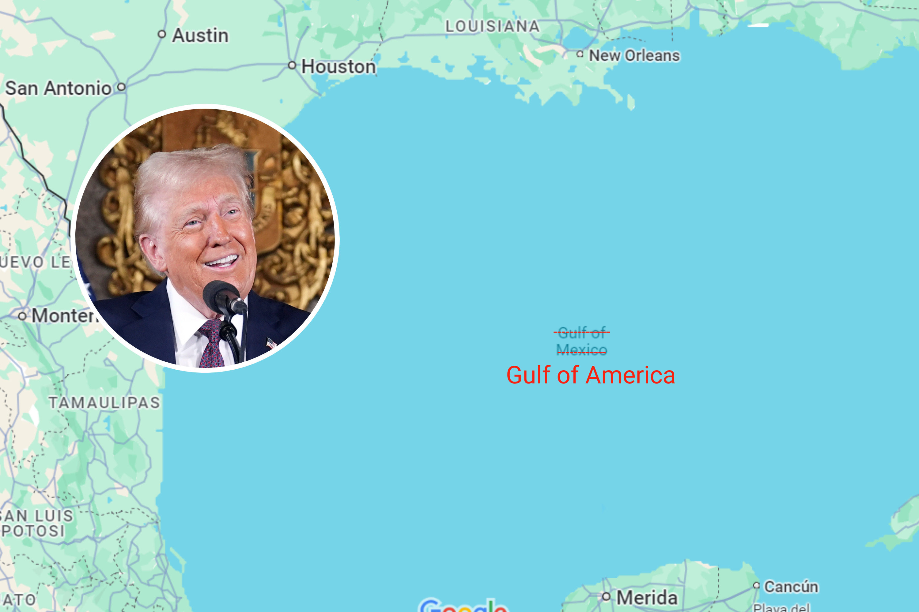
The United States Department of the Interior, acting under directives originating from the Trump administration, has initiated a process to rename significant geographical features, most notably the Gulf of Mexico and Denali. This executive action will necessitate corresponding updates to mapping services worldwide, with Google Maps being a primary entity expected to implement these changes. The ramifications extend beyond mere cartographic adjustments, impacting a wide array of industries reliant on accurate geographical data, including navigation, logistics, research, and public safety. This article will delve into the technical, logistical, and economic implications of Google Maps adapting to these new US geographical designations, examining the challenges and processes involved in such a large-scale data update.
The renaming of prominent geographical features like the Gulf of Mexico and Denali is not a novel occurrence in US history. However, the impetus behind the current changes, stemming from executive orders, introduces a distinct political dimension that distinguishes it from previous, often community-driven, appellation adjustments. The United States Board on Geographic Names (BGN), the official body responsible for standardizing geographic nomenclature in the United States, is the primary agency tasked with approving and implementing these changes. Once the BGN officially ratifies the new names, the United States government will recognize these designations for all official purposes. This governmental recognition is the trigger for external entities, such as Google, to initiate their own update processes. The significance of a name change for a body of water as vast and economically vital as the Gulf of Mexico, or a mountain as iconic as Denali (formerly Mount McKinley), cannot be overstated. These names are embedded in historical records, scientific literature, maritime charts, and the collective consciousness of millions.
For Google Maps, the update process is a complex undertaking. The platform relies on a massive and continuously updated database of geographical information, sourced from a multitude of contributors, including government agencies, commercial data providers, and user-generated content. The BGN’s decisions serve as the authoritative source for US geographical names, and Google, like other major mapping services, adheres to these official designations for accuracy and consistency. The technical challenge lies in identifying all instances where the old names are used within Google’s vast dataset and systematically replacing them with the new, officially sanctioned names. This involves not only the primary label displayed on the map but also associated metadata, search queries, and internal database keys. The sheer scale of Google Maps, covering the entire globe, means that even a single major geographical name change requires meticulous cross-referencing and updating across numerous data layers.
The process of updating Google Maps typically involves several stages. Firstly, Google’s data acquisition teams will receive official notification from the BGN or relevant US government agencies regarding the name changes. This notification will likely include precise geographical boundaries and the exact new appellations. Following this, data engineers and scientists will begin the intricate task of locating all occurrences of the old names within Google’s internal geographic information systems (GIS). This involves querying databases, analyzing geographic vector data, and reviewing raster imagery and associated textual information. The system is designed to be robust, but the potential for legacy data or older versions of information to contain the former names necessitates a thorough and comprehensive audit.
Furthermore, Google employs a sophisticated system of machine learning and artificial intelligence to assist in data validation and updating. Algorithms are trained to recognize geographical features and their associated names. However, when a name change occurs, these algorithms need to be retrained or updated to reflect the new reality. This involves feeding the AI models with the official new names and ensuring they can correctly associate them with the relevant geographical entities. The goal is to achieve a seamless transition for users, where searching for "Gulf of Mexico" or "Denali" automatically directs them to the correct location with the updated nomenclature.
The impact of these geographical name changes on search engine optimization (SEO) is a significant consideration. Businesses, websites, and content creators that reference the Gulf of Mexico or Denali in their online presence will need to update their content to reflect the new official names. Failure to do so could result in diminished search visibility for users searching with the updated terminology. For instance, a travel agency promoting cruises in the "Gulf of Mexico" will need to adapt its website copy, social media posts, and digital advertising campaigns to include or predominantly use the new name. This proactive adjustment is crucial to maintain relevance in search engine results and to ensure that potential customers can find their offerings. The keyword landscape surrounding these geographical features will undoubtedly shift, requiring SEO professionals to re-evaluate and adapt their strategies.
The economic ramifications are substantial, particularly for industries directly dependent on accurate geographical referencing. The maritime industry, for example, relies heavily on precise charts and navigational data. Shipping companies, fishing fleets, and offshore energy providers will need to update their nautical charts, navigation systems, and operational protocols. The cost of updating these systems and training personnel can be considerable. Similarly, the tourism sector, which often uses geographical names as key selling points, will need to recalibrate its marketing materials and online presence. Hotels, tour operators, and travel guide websites will all face the task of updating their content.
For scientific research, particularly in fields like oceanography, climatology, and geology, accurate and consistent nomenclature is paramount for data integrity and reproducibility. Researchers publishing papers or accessing existing datasets will need to be aware of and adopt the new official names. This could involve updating bibliographies, re-analyzing historical data, and ensuring that all future research publications adhere to the new designations. The potential for confusion or misinterpretation of data if older, unofficial names persist in scientific literature is a serious concern that will require diligent attention from the research community.
Public safety agencies, including emergency services and disaster management organizations, also depend on accurate geographical information for dispatching resources and communicating critical information. While these agencies typically have robust internal systems, the transition to new official names for major geographical features will require updates to their databases, training materials, and communication protocols. Ensuring that emergency responders can quickly and accurately identify and locate areas within or adjacent to the designated features is a critical operational necessity.
The process of updating a global platform like Google Maps is iterative. While the primary official names will be updated promptly, there may be a period of transition where both old and new names are recognized to accommodate the gradual adoption by users and businesses. Google’s algorithm for handling search queries is sophisticated enough to often understand user intent even with outdated terminology, but the ultimate goal is to align the platform with the official geographical record. The company’s commitment to providing accurate and up-to-date information means they will prioritize the integration of these new names across their suite of products, including Google Earth, Google Assistant, and other location-aware services.
The underlying data for Google Maps is a complex mosaic. It includes data from government agencies like the National Oceanic and Atmospheric Administration (NOAA) for coastal features and the U.S. Geological Survey (USGS) for terrestrial features. These agencies will be the first to adopt and disseminate the new names, and Google will likely integrate this official data directly. Beyond governmental data, Google also utilizes data from commercial providers and relies on user contributions through Google Maps’ “Contribute” feature. While official government designations take precedence, the sheer volume of user-generated content means that the transition may take some time to fully propagate across all aspects of the platform. User reports and edits submitted after the official name change will help to accelerate the adoption process on the ground.
The potential for backlash or differing opinions regarding the name changes is also a factor that Google, as a global entity, must consider. While the company generally adheres to official governmental decisions for geographic nomenclature, major changes can sometimes be contentious. In such instances, Google’s approach typically involves prioritizing the official designation while also potentially acknowledging historical or alternative names where appropriate, particularly in less prominent contexts or for informational purposes. However, for a feature as significant as the Gulf of Mexico or Denali, the primary focus will be on implementing the officially sanctioned name. The geopolitical context of such changes, and their potential implications for international relations and regional identity, are considerations that extend beyond the purely technical task of data updating.
In conclusion, the imminent updates to Google Maps reflecting the US government’s renaming of the Gulf of Mexico and Denali represent a significant undertaking for the technology giant. This process involves intricate data management, algorithmic adjustments, and a keen awareness of the downstream impacts on SEO, various industries, and public information dissemination. The accuracy and completeness of Google Maps are vital for millions of users worldwide, and the company’s ability to swiftly and effectively integrate these official geographical name changes will be a testament to its sophisticated data infrastructure and its commitment to maintaining a globally recognized and authoritative mapping service. The transition, while technically challenging, is a necessary step to ensure that Google Maps continues to provide reliable and up-to-date geographical information in alignment with official governmental designations.


