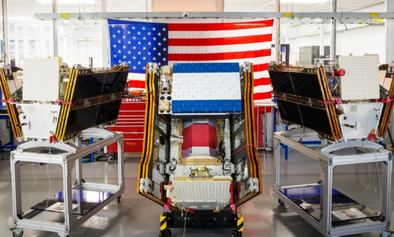
As vast plumes of smoke from hundreds of burning wildfires continue to blanket regions across Canada and the United States, casting a pall over major cities and inflicting hazardous air pollution on millions, a significant technological advancement has taken flight. On July 7, 2026, the first three operational satellites of the Google-backed FireSat program successfully launched into orbit aboard a SpaceX Falcon 9 rocket from Vandenberg Space Force Base in California. This deployment marks a pivotal transition to "initial operational capability" for the FireSat constellation, managed by the nonprofit Earth Fire Alliance, promising a new era in wildfire detection that aims to spot even nascent blazes often missed by existing satellite systems. Following a rigorous three-month testing period, these microsatellites are slated to begin actively providing critical wildfire data to fire agencies across the United States, Australia, and Europe before the end of the year.
The FireSat Initiative: A New Era in Wildfire Surveillance
The FireSat constellation represents a groundbreaking, purpose-built satellite network specifically engineered for early wildfire detection. Unlike conventional satellites, which may not be optimized for the unique spectral signatures of nascent fires or struggle to penetrate dense smoke cover, FireSat’s design incorporates advanced multispectral imaging capabilities. These sensors are capable of peering through thick smoke and clouds, detecting fires as small as five by five meters—approximately 16 by 16 feet—a level of granularity previously unattainable for wide-area surveillance. This precision is vital, as early detection can mean the difference between a controllable blaze and a catastrophic inferno.
The development and deployment of these sophisticated satellites have been a collaborative effort. California-based satellite manufacturer Muon Space designed and built the microsatellites, bringing cutting-edge aerospace engineering to the forefront of environmental monitoring. The initiative has garnered substantial financial backing from prominent philanthropic and corporate entities. Google has committed over $15 million to support the initial deployment phases, recognizing the profound potential of AI-driven satellite imagery in climate resilience efforts. Further bolstering the program, the Bezos Earth Fund pledged a significant $26 million, underscoring the broad philanthropic commitment to addressing the global wildfire challenge.
The efficacy of FireSat’s technology was demonstrably proven by a Protoflight satellite launched in March 2025. This precursor mission collected more than one million images, showcasing its ability to identify low-intensity blazes that were invisible to existing satellite infrastructure. This successful protoflight validated the core technological premise, paving the way for the operational constellation.

Phased Rollout and Global Reach
With the initial trio of operational satellites now in orbit, the Earth Fire Alliance is poised to expand its network and data delivery. After the initial testing phase concludes, the satellites will commence providing data services, ensuring coverage of every fire-prone region on Earth at least twice per day. This regular revisit rate is critical for monitoring dynamic wildfire conditions.
The "early adopter" organizations slated to integrate FireSat data into their operations this year include leading fire agencies in California, known for its intense wildfire seasons; Colorado, which faces significant wildland-urban interface challenges; and international partners in Australia and Portugal, both countries grappling with escalating fire risks. This initial cohort will provide invaluable feedback as the constellation expands and its data streams are refined.
Looking ahead, the FireSat program has ambitious expansion plans. As more satellites are launched, the aim is to achieve hourly imagery updates anywhere in the world by 2029. This rapid revisit rate will significantly enhance situational awareness for fire managers, allowing for quicker response times and more effective resource allocation. The ultimate vision entails a full constellation of more than 50 satellites, projected to be in orbit by the early 2030s, which would enable imagery updates every 20 minutes. Such near real-time data would provide an unprecedented level of surveillance, transforming how wildfires are detected, tracked, and managed globally.
Projected Impact: Economic, Environmental, and Human Benefits
The potential benefits of FireSat’s enhanced detection capabilities are far-reaching, encompassing significant economic, environmental, and human impacts. The Earth Fire Alliance has projected that even an hourly revisit rate from the FireSat constellation could lead to substantial savings and protection. Specifically, it is estimated that this improved early detection could help save more than $1 billion in fire damage costs annually. Furthermore, it could prevent nearly 22 million tons of carbon emissions, a crucial contribution to mitigating climate change. On the human and ecological front, FireSat is projected to protect 3,500 homes and safeguard 1.3 million acres of land from the destructive force of wildfires.
To maximize the utility of the data, Google Research plans to integrate the operational FireSat data with its advanced AI models. This will involve comparing new satellite imagery with historical data to accurately identify very small fires and to inform sophisticated predictive modeling of wildfire behavior. By leveraging artificial intelligence, FireSat aims not only to detect fires but also to anticipate their spread and intensity, providing fire agencies with critical foresight. Google celebrated the launch of the first operational FireSat satellites as "another tangible step forward in putting practical AI to work for climate resilience," highlighting the company’s commitment to applying its technological prowess to urgent environmental challenges.

The Broader Wildfire Crisis: A Climate Change Imperative
While FireSat offers a promising technological solution, it operates within the broader context of a worsening global wildfire crisis, inextricably linked to climate change. Across the planet, rising temperatures, prolonged droughts, and altered precipitation patterns are creating drier landscapes and longer fire seasons, making forests and wildlands more susceptible to ignition and rapid spread. The frequency and intensity of extreme fire events have escalated dramatically in recent decades, overwhelming traditional firefighting resources and strategies.
The widespread wildfires that have ravaged Canada and parts of the United States this summer of 2026 serve as a stark illustration of this escalating crisis. As of July 17, 2026, the Canadian Wildland Fire Information System reported nearly 900 active wildfires across the country. To date, Canada has experienced more than 3,600 wildfires, scorching over 6.6 million acres—an area larger than the state of Maryland. These fires have generated massive smoke clouds, causing severe air quality alerts across Canadian and US cities, impacting the health and daily lives of more than 100 million people. First Nations communities, often located in remote forested areas, have been disproportionately affected, with thousands forced to evacuate their homes due to the fast-moving blazes.
Canada’s Fiery Summer of 2026: A Case Study
The Canadian wildfire season of 2026 follows two of the country’s most destructive seasons in 2023 and 2025, with the last three years ranking among the ten worst on record. This pattern underscores a worrying trend of increasing fire activity and severity. Werner Kurz, a retired senior research scientist at Natural Resources Canada, articulated the grim reality to The Atlantic, stating, "What is unfolding is what climate and forest scientists have been predicting for 30 years. That as the world gets hotter and drier, we are exposing forests to more and more risk, and the old strategies of fire suppression are simply being overwhelmed."
Fighting wildfires in Canada’s vast, often uninhabited boreal forests presents unique challenges. Effective suppression relies heavily on specialized resources such as fixed-wing air tankers capable of dropping fire retardants and heavy-lift helicopters for water bombing and transporting firefighting crews to remote sites. However, the burden of acquiring and contracting for such expensive aircraft traditionally falls to individual Canadian provinces. In recent years, the sheer scale of the fires has meant that every available aircraft has frequently been required, stretching resources thin. In response to these growing demands, the Canadian government recognized the urgent need for enhanced national capacity and, in May 2026, leased 10 new aerial firefighting aircraft, making them available as surge assets to provinces facing critical wildfire situations.
Despite these efforts, the current situation highlights the limitations of even well-equipped fire agencies. Dozens of wildland fires across Canada are currently designated as "out of control" and are simply being monitored rather than actively suppressed. This difficult decision is often necessitated by the overwhelming number of active fires, the limited availability of resources, and the imperative to prioritize firefighter safety when facing uncontrollable infernos in remote or high-risk areas.

The Paradox of Progress: AI’s Climate Footprint
While Silicon Valley’s innovative drive to deploy AI models for wildfire detection is commendable and desperately needed, it also brings to light a complex paradox: the considerable climate costs associated with the very technologies being championed. The burgeoning demand for artificial intelligence requires massive computational power, necessitating the construction and operation of increasingly large AI data centers. These facilities consume enormous amounts of electricity, and alarmingly, a significant portion of this energy demand in the United States is currently being met by new natural gas projects. This reliance on fossil fuels for AI infrastructure could collectively emit more than 129 million tons of greenhouse gases per year, contributing to the very climate change that fuels the wildfire crisis.
Google, a leading proponent of AI development and a key backer of FireSat, has itself acknowledged the challenges inherent in sourcing enough clean energy to offset the potential emissions from its energy-hungry data centers. The company reported a 37 percent increase in its company-wide electricity usage in 2025, driven in part by its rapid AI buildout. This highlights a critical tension: while AI offers powerful tools for climate resilience, its unchecked growth and reliance on carbon-intensive energy sources could exacerbate the problem it aims to solve.
Looking Ahead: A Multi-faceted Approach to Fire Resilience
Google’s financial and technical support for AI-powered wildfire detection through the FireSat program represents a crucial step forward in enhancing our ability to respond to environmental emergencies. However, wildfire detection, no matter how advanced, is but one component of a comprehensive strategy required to prevent blazes from spiraling out of control. Fire agencies globally require not only early warning systems but also sufficient resources for proactive ecosystem management, including prescribed burns to reduce fuel loads, and robust capabilities for actively suppressing unwanted fires. Their mission has become increasingly challenging due to the accelerating impacts of global warming.
The FireSat constellation offers a beacon of hope in the fight against devastating wildfires, providing an unprecedented ability to "peer through the smoke" and detect fires at their earliest stages. This technological leap, coupled with Google’s AI capabilities, holds immense promise for mitigating damage, protecting lives, and preserving ecosystems. Yet, for true climate resilience, this innovation must be integrated into a broader, multi-faceted approach that addresses the root causes of the wildfire crisis, including aggressive climate action to reduce greenhouse gas emissions, sustainable land management practices, and adequate funding for firefighting agencies worldwide. Only through such a holistic strategy can humanity hope to navigate the escalating challenges posed by a warming planet and its fiery consequences.