Google-Backed FireSat Satellites Launch Amid Escalating Wildfire Crisis, Offering Unprecedented Detection Capabilities

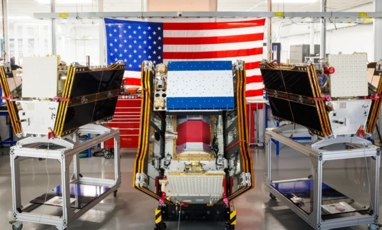
As smoke from hundreds of raging wildfires blanketed vast swathes of Canada and the United States, the initial trio of operational satellites in the groundbreaking Google-backed FireSat program successfully achieved orbit. This pivotal launch, which occurred on July 7, 2026, aboard a SpaceX Falcon 9 rocket from Vandenberg Space Force Base in California, marks a significant leap forward in global wildfire detection capabilities. Following a crucial three-month testing period, these advanced microsatellites are poised to begin providing critical wildfire detection data to fire agencies across the United States, Australia, and Europe before the year’s end, with a promise of detecting even the smallest of blazes that might otherwise go unnoticed.
This deployment signifies a transition to "initial operational capability" for the FireSat constellation, a pioneering initiative managed by the nonprofit Earth Fire Alliance. The program represents the world’s first satellite constellation purpose-built and dedicated solely to the detection of wildfires, designed to overcome the limitations of existing satellite systems that often miss nascent fires obscured by smoke or clouds.
A New Era in Wildfire Detection Technology
The FireSat system is engineered to provide unparalleled precision in identifying wildfire ignitions. Each satellite, meticulously designed and manufactured by California-based Muon Space, is equipped with state-of-the-art multispectral imaging technology. This sophisticated instrumentation allows the satellites to "peer through smoke and clouds," a capability crucial for early detection in conditions that render traditional optical sensors ineffective. The system boasts the ability to pinpoint fires as minute as five by five meters—approximately 16 by 16 feet—a level of detail previously unattainable from orbit on a consistent basis.
The efficacy of this technology was unequivocally demonstrated by a FireSat Protoflight satellite launched in March 2025. During its operational phase, this precursor satellite collected over one million images, proving its capacity to detect low-intensity blazes that were entirely invisible to other existing satellite networks. This protoflight mission validated the core technological premise of FireSat, paving the way for the full constellation’s deployment and instilling confidence in its operational success.
Strategic Funding and Collaborative Vision
The FireSat program is a testament to significant philanthropic and corporate investment, underscoring a growing recognition of the urgent need for advanced wildfire solutions. Google has committed over $15 million to support the initial deployment phases, reflecting its strategic interest in leveraging technology and artificial intelligence for climate resilience. In a blog post celebrating the launch, Google emphasized the event as "another tangible step forward in putting practical AI to work for climate resilience," highlighting its dual commitment to technological innovation and environmental stewardship.
Further substantial financial backing has come from the Bezos Earth Fund, which pledged an impressive $26 million to the initiative. This commitment aligns with the fund’s broader mission to combat climate change and protect nature through impactful investments in innovative solutions. The nonprofit Earth Fire Alliance, serving as the constellation’s managing entity, orchestrates the collaboration between technology developers, funders, and end-users, ensuring the data effectively reaches those on the front lines of wildfire management. This multi-stakeholder approach underscores the complexity and collaborative nature required to address a global challenge of this magnitude.

Phased Rollout and Transformative Impact Projections
The FireSat constellation’s operational rollout is planned in strategic phases to maximize its impact. Following the initial testing, the first three satellites will provide data to fire agencies in the specified "early adopter" regions of California, Colorado, Australia, and Portugal. These regions, frequently ravaged by severe wildfire seasons, will serve as crucial proving grounds for the system’s real-world effectiveness.
As more satellites are progressively launched, the FireSat program aims for an ambitious expansion of its coverage. By 2029, the constellation is projected to provide the latest imagery anywhere in the world on an hourly basis, drastically reducing the time between fire ignition and detection. The ultimate vision entails a full constellation of more than 50 satellites by the early 2030s, which would enable a staggering revisit rate of every 20 minutes. This near real-time intelligence would revolutionize wildfire response strategies, allowing fire agencies to dispatch resources far more rapidly to contain blazes before they escalate into uncontrollable infernos.
The Earth Fire Alliance has presented compelling projections regarding the potential benefits of this enhanced detection capability. Even an hourly revisit rate from the FireSat constellation is estimated to prevent over $1 billion in fire damage costs annually. This economic saving is primarily attributed to the ability to detect and suppress small fires quickly, avoiding the exponential costs associated with large-scale, prolonged firefighting efforts. Furthermore, the program is projected to prevent nearly 22 million tons of carbon emissions—equivalent to taking millions of cars off the road—by curbing the spread of large, carbon-releasing wildfires. Crucially, it is also expected to protect 3,500 homes and safeguard 1.3 million acres of land from destruction. These figures underscore the profound environmental, economic, and social dividends anticipated from the FireSat initiative.
The Indispensable Role of Artificial Intelligence
Central to FireSat’s effectiveness is the integration of advanced artificial intelligence models developed by Google Research. These AI algorithms are designed to process the vast streams of multispectral data transmitted from the satellites. By comparing operational FireSat data with extensive historical images, the AI can accurately identify even minute fire signatures, distinguish them from non-fire hot spots (such as industrial activity or agricultural burns), and track their evolution. This sophisticated analysis moves beyond mere detection, feeding into predictive modeling of wildfires.
These predictive models, informed by real-time data and historical patterns, can forecast fire spread, intensity, and potential impact zones, providing fire agencies with invaluable foresight. Such capabilities enable more strategic resource allocation, including the pre-positioning of firefighting crews and equipment, and more timely evacuation orders. Google’s explicit articulation of this as "putting practical AI to work for climate resilience" emphasizes the company’s commitment to harnessing its technological prowess for tangible environmental solutions.
The Broader Wildfire Crisis and the Climate Change Imperative
The launch of FireSat occurs against a backdrop of an escalating global wildfire crisis, inextricably linked to anthropogenic climate change. Scientific consensus, echoed in numerous reports from bodies like the Intergovernmental Panel on Climate Change (IPCC), indicates that rising global temperatures, prolonged droughts, and increased fuel loads are creating conditions conducive to more frequent, intense, and destructive wildfires worldwide. Regions historically susceptible to wildfires, such as the American West, Australia, and the Mediterranean basin, are experiencing unprecedented fire seasons, while areas like Canada’s boreal forests are witnessing blazes of a scale and intensity rarely seen before.

The economic and social costs of this crisis are staggering. Beyond the immediate destruction of property and ecosystems, wildfires inflict severe health impacts through hazardous air pollution, disrupt critical infrastructure, and displace millions of people annually. The ecological damage is profound, contributing to biodiversity loss, long-term forest degradation, and further exacerbating climate change through massive carbon emissions.
The Paradox: AI’s Climate Cost vs. Climate Solution
While Google’s financial and technical support for AI-powered wildfire detection offers a powerful tool, it also highlights a critical paradox: the considerable climate costs associated with the very technology being deployed to combat climate change. The rapid expansion of artificial intelligence, particularly large language models and complex analytical systems, necessitates massive data centers that consume enormous amounts of electricity.
The energy demand of these AI data centers is soaring. Projections indicate that the greenhouse gases emitted from the boom in data center construction and operation in the United States alone could collectively exceed 129 million tons per year. To put this into perspective, this figure rivals the annual emissions of some small industrialized nations. Google itself has publicly acknowledged the immense challenge of deploying enough clean energy projects to offset the burgeoning emissions from its energy-hungry data centers. The company reported a significant 37 percent increase in its company-wide electricity usage in 2025, largely driven by its AI buildout. This "green paradox" raises important questions about the overall carbon footprint of digital solutions and the urgent need for sustainable energy transitions within the tech sector.
Beyond Detection: A Holistic Approach to Fire Management
Effective wildfire management requires a multi-faceted approach, and while FireSat’s early detection capabilities are revolutionary, they represent just one critical element. Fire agencies globally emphasize that robust wildfire prevention, mitigation, and suppression strategies are equally vital. This includes proactive forest and land management through prescribed burns, which mimic natural fire cycles to reduce hazardous fuel loads and promote ecosystem health. Fuel reduction efforts, such as thinning forests and creating defensible spaces around communities, also play a crucial role.
Moreover, fire agencies require sufficient ground and aerial resources—including firefighters, fixed-wing air tankers, and heavy-lift helicopters—to manage ecosystems and swiftly suppress unwanted fires. The increasing scale and intensity of wildfires, fueled by global warming, are placing unprecedented strain on these resources, often overwhelming existing capacities.
Case Study: The Canadian Wildfire Crisis of 2026
The severe wildfire season unfolding in Canada’s boreal forests in the summer of 2026 provides a stark illustration of these challenges. As of July 17, the Canadian Wildland Fire Information System reported nearly 900 active wildfires across the country, contributing to a year-to-date total of over 3,600 blazes that have incinerated more than 6.6 million acres of land. The sheer magnitude of these fires has forced thousands of people, particularly residents of First Nations communities, to evacuate their homes, highlighting the disproportionate impact on Indigenous populations.

The environmental consequences have extended far beyond Canada’s borders. Massive smoke plumes generated by these fires have drifted across Canadian and US cities, inflicting hazardous air pollution upon more than 100 million people, from the Midwest to the Mid-Atlantic and Northeast United States. This ongoing crisis underscores a grim reality: Canada has experienced two of its most destructive wildfire seasons in 2023 and 2025, with the last three seasons consistently ranking among the ten worst on record.
Werner Kurz, a retired senior research scientist at Natural Resources Canada, encapsulated the dire situation in an interview with The Atlantic: "What is unfolding is what climate and forest scientists have been predicting for 30 years. That as the world gets hotter and drier, we are exposing forests to more and more risk, and the old strategies of fire suppression are simply being overwhelmed."
The logistical challenges of fighting fires in vast, often remote, boreal regions are immense. While aerial assets like air tankers dropping retardants and helicopters transporting crews are essential, individual Canadian provinces typically bear the financial burden of acquiring or contracting these vital resources. In recognition of the escalating crisis, the Canadian federal government stepped in this year, leasing 10 new aerial firefighting aircraft to serve as surge assets for provinces facing overwhelming fire activity. Despite these efforts, dozens of "out of control" wildland fires are simply being monitored rather than actively suppressed—a difficult but necessary decision fire agencies are forced to make when managing limited resources and prioritizing firefighter safety.
Conclusion: A Critical Tool in a Broader Battle
The launch of the FireSat constellation represents a monumental advancement in humanity’s capacity to detect and respond to wildfires. By offering unprecedented early detection capabilities, supported by AI-driven analysis, it promises to mitigate the devastating impacts of these escalating natural disasters, saving lives, homes, ecosystems, and significant economic resources.
However, FireSat is a critical tool within a much larger, complex battle. The underlying drivers of the wildfire crisis—global warming fueled by greenhouse gas emissions—remain an urgent global priority. While technology offers powerful solutions for adaptation and response, it must be complemented by aggressive climate action, sustainable land management practices, and robust investment in traditional firefighting resources. The paradox of AI’s energy footprint also serves as a potent reminder that even as we innovate to solve climate challenges, we must simultaneously address the environmental impact of our technological progress. The success of FireSat will ultimately be measured not just by the fires it detects, but by how effectively it empowers humanity to protect our planet in an era defined by accelerating climate change.