Chicago Launches Nation’s Largest Hyperlocal Air Quality Network to Combat Environmental Inequity and Climate-Driven Smog
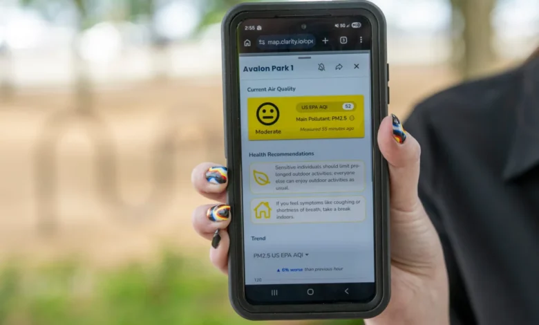

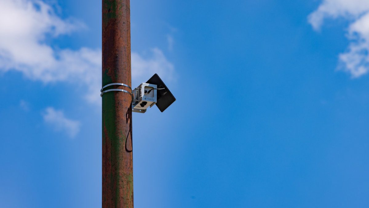
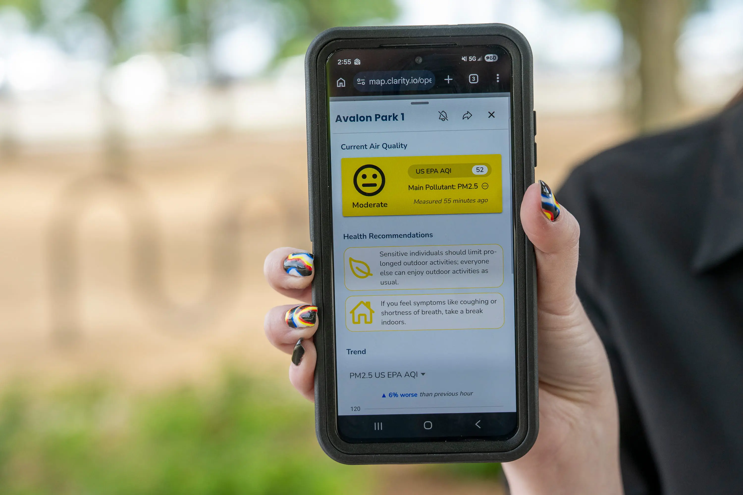
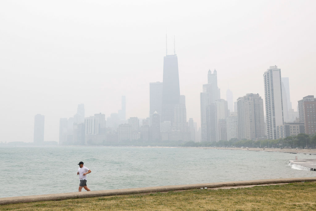
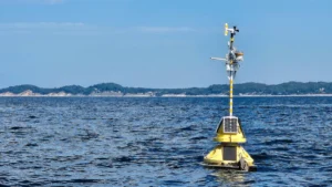
As the midday sun glints off the glass facades of Chicago’s Loop, Serap Erdal, a professor of environmental and occupational health sciences at the University of Illinois Chicago, pauses at a nondescript light pole in Grant Park. Her focus is not on the bustling traffic of Michigan Avenue or the cyclists weaving through the park, but on a small, metallic silver box fixed high above the sidewalk. Roughly the size of a tissue box and powered by a compact solar panel, this device is one of 277 sensors that now form the backbone of the most extensive community-led air quality monitoring network in the United States. Through a dedicated mobile application, Erdal monitors a digital map of the city, watching for the color-coded indicators that reveal the invisible composition of the air Chicagoans breathe.
On this particular June afternoon, a bright green dot appears on her screen. The Air Quality Index (AQI) at this downtown location stands at 31—a "good" rating according to Environmental Protection Agency (EPA) standards, signifying minimal risk to public health. While the breezy, clear conditions have kept pollutants uniform across most of the city, the "Open Air Chicago" project is designed to capture the moments when that uniformity shatters. Even on this clear day, a solitary monitor on the city’s far South Side flickers with a different hue, hinting at the localized industrial emissions and heavy freight traffic that define life in the city’s overburdened Black and Latino neighborhoods.
The Genesis of Open Air Chicago: A History of Environmental Justice
The implementation of the Open Air Chicago network is not merely a technological milestone; it is the direct result of a protracted legal and social battle over environmental racism. The project’s origins trace back to 2019, when the city of Chicago faced intense backlash for its plan to facilitate the relocation of General Iron, a major scrap-metal shredding operation, from the affluent, majority-white Lincoln Park neighborhood to the Southeast Side. The proposed site was situated in a predominantly Latino and Black community already grappling with a legacy of industrial pollution from steel mills and petroleum coke facilities.
In 2021, a coalition of local environmental activists and community organizations filed a landmark civil rights complaint with the federal Department of Housing and Urban Development (HUD). The complaint alleged that the city’s zoning and permitting decisions were discriminatory, disproportionately burdening low-income communities of color with hazardous industrial activity while shielding wealthier areas. This legal pressure culminated in a 2023 settlement agreement between the city and community groups. A central pillar of this settlement was the creation of a comprehensive, hyperlocal air monitoring system to provide the transparent data that residents had long demanded.
The city partnered with the University of Illinois Chicago (UIC) to launch the initiative last fall, committing over $4 million to cover operations and data analysis through the beginning of 2030. For leaders like Oscar Sanchez, director of the Southeast Environmental Task Force, the network represents a shift from anecdotal evidence to empirical authority. For decades, residents of the South and West Sides reported higher rates of respiratory distress, but lacked the time-stamped, localized data to prove the correlation between their health and nearby industrial spikes. The new system aims to end what Sanchez describes as the "gaslighting" of vulnerable communities regarding their own lived experiences.

Technical Scope and the Science of Urban Pollutants
The Open Air Chicago network utilizes low-cost sensor technology to provide a high-resolution map of urban air quality, with monitors placed less than a mile apart in many areas. While the EPA maintains a limited number of "gold standard" regulatory-grade monitors—which are highly precise but expensive and sparse—the community network prioritizes density and frequency. These 277 sensors capture over 20,000 data points daily, focusing on two primary pollutants that pose the greatest risk to urban populations:
- Nitrogen Dioxide (NO2): Primarily a byproduct of fossil fuel combustion from vehicles, power plants, and industrial boilers, NO2 is a precursor to ground-level ozone. Long-term exposure is linked to the development of asthma and increased susceptibility to respiratory infections.
- Fine Particulate Matter (PM2.5): These microscopic particles, measuring 2.5 micrometers or less in diameter, are particularly dangerous because they can bypass the body’s natural respiratory defenses. They are capable of entering the bloodstream and traveling to vital organs, contributing to cardiovascular disease, lung cancer, and premature mortality.
Recent scientific literature, including a 2023 study published in Nature Communications, has identified PM2.5 as the world’s leading environmental health risk factor. In Chicago, where the Chicago Health Atlas reports that adult asthma rates in some South Side neighborhoods are nearly double the citywide average, the ability to track these particles in real-time is a matter of life and death.
The Convergence of Climate Change and Seasonal Smog
As the network enters its first full summer of operation, researchers are bracing for the "ozone season." In the Midwest, the combination of high temperatures and intense sunlight triggers a chemical reaction between nitrogen oxides and volatile organic compounds (VOCs) to form ground-level ozone—the primary component of smog. Climate change is actively exacerbating this process by lengthening the duration of summer heatwaves and creating stagnant air conditions that trap pollutants near the surface.
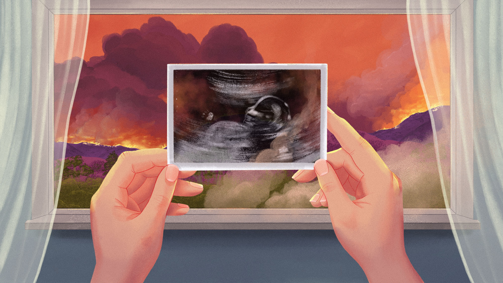
Daniel Horton, an assistant professor of Earth and planetary sciences at Northwestern University, notes that the Midwest is facing a dual threat: locally generated pollution and the "transported" pollution from distant wildfires. The 2023 wildfire season in Canada provided a harrowing preview of this new reality. In June 2023, smoke plumes traveled south, turning Chicago’s skies a hazy orange and briefly giving the city the worst air quality of any major metropolitan area in the world.
A study published in Atmospheric Environment earlier this year revealed that the 2023 wildfire smoke raised Chicago’s ground-level ozone by nearly 10 percent of the federal limit. The impact was not felt equally; the study found that central, western, and southeastern neighborhoods were most severely affected. This trend is part of a broader national reversal. According to a June 2024 report in the journal Science, stricter federal regulations had successfully reduced ozone-forming gases by 11 percent between 2003 and 2015. However, since 2015, the increasing frequency and intensity of wildfires have undone roughly one-third of those gains, leading to an estimated 318 additional premature deaths per year across the U.S.
Bridging the Gap: Satellites vs. Surface Sensors
One of the most critical roles for the Open Air Chicago network is validating data from other sources. While NASA satellites provide a global view of air pollution, they often struggle to distinguish between smoke or smog high in the atmosphere and the air being breathed at street level. Carl Malings, a researcher at Morgan State University and NASA’s Goddard Space Flight Center, explains that satellite data can sometimes show a dense plume of smoke that is actually passing safely overhead.
By contrast, the Chicago network’s sensors are positioned at the "breathing zone." This ground-level perspective allows officials to determine exactly when atmospheric pollutants descend to the surface, providing more accurate health alerts for sensitive populations, such as children, the elderly, and those with pre-existing heart and lung conditions.
Policy Implications and Future Outlook
The data collected through 2029 is intended to serve as more than just a public information tool; it is expected to reshape the city’s approach to urban planning and industrial permitting. By identifying "hot spots"—areas where pollution levels are consistently higher than the city average—the Chicago Department of Public Health can develop targeted interventions. This could include rerouting heavy truck traffic away from residential zones, implementing stricter emissions controls on specific industrial corridors, or increasing the urban tree canopy to mitigate heat and filter particulates.
The project also sets a precedent for other major U.S. cities. As urban centers face the mounting challenges of climate change and environmental inequity, the Chicago model demonstrates how community-led advocacy can be translated into a sophisticated, data-driven governance framework.
For Professor Serap Erdal and the team at UIC, the ultimate goal is a permanent expansion of the network. "We hope we’ll strengthen the network in the future," Erdal says, emphasizing the need to measure a broader range of pollutants and ensure the data remains accessible to every Chicagoan. As the city navigates a future of hotter summers and more frequent wildfires, the silver boxes on Chicago’s light poles stand as silent sentinels, ensuring that the fight for clean air is grounded in undeniable fact. Through this unprecedented transparency, Chicago is finally moving toward a future where a resident’s zip code no longer determines the quality of the air they breathe.


