Update Winter Weather Advisory For The Greater Lake Tahoe Area Until Friday Night Up To 7 Inches Of Snow
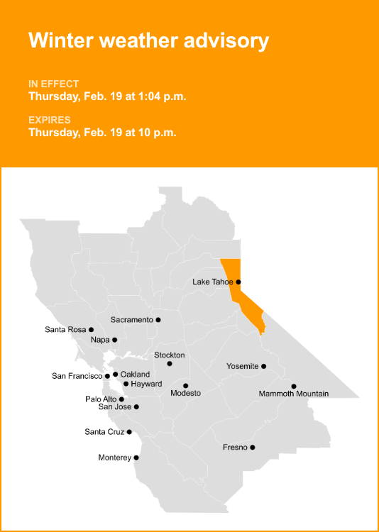
Winter Weather Advisory Issued for Greater Lake Tahoe Area Until Friday Night: Up to 7 Inches of Snow Expected
The National Weather Service has issued a Winter Weather Advisory for the greater Lake Tahoe area, including communities like South Lake Tahoe, Truckee, Incline Village, Stateline, and surrounding mountain passes. This advisory is in effect until Friday night, with the potential for accumulating snowfall, primarily in the higher elevations, but also impacting lower lake level areas. Forecast models indicate that between 2 to 7 inches of snow are possible across the region, with the highest accumulations expected at elevations above 7,000 feet. This snowfall, coupled with gusty winds, could lead to hazardous travel conditions throughout the advisory period, particularly for commuters and those planning outdoor winter activities. Motorists are strongly advised to exercise extreme caution, allow for significantly longer travel times, and be prepared for slick roads and reduced visibility.
The specific timing and intensity of the precipitation remain a key focus for meteorologists monitoring this system. Current projections suggest that snow will begin to develop late Wednesday and continue intermittently through Friday. While the snow levels are expected to fluctuate, they are forecast to lower to near lake level at times, meaning that even lakeside communities could experience some accumulations. This is particularly noteworthy for areas that have not yet seen significant snowfall this season. The transition from rain to snow is a possibility in some lower-elevation zones, depending on the precise temperature profiles during the event. The advisory emphasizes the likelihood of patchy snow and ice development, especially on untreated roadways, sidewalks, and hiking trails. Travelers venturing into the Sierra Nevada, particularly along major corridors like Interstate 80 and U.S. Highway 50, should anticipate winter driving conditions. Chain controls, a common feature of Sierra winter weather, are a strong possibility, and drivers without appropriate snow tires or chains may face restrictions.
Understanding the nuances of this winter weather event is crucial for effective preparation and safety. The 2 to 7 inches of snow forecast represents a range, and localized variations are highly probable. Higher elevations, such as the peaks of the Sierra Nevada and the upper reaches of the ski resorts, are the most likely to receive the higher end of the snow accumulation predictions, potentially exceeding 7 inches. These areas are also more prone to stronger winds. Lower elevations, including the towns situated at or near the lake’s surface, may see less snow, possibly in the 1 to 3-inch range, but even this amount can create hazardous conditions on roads and sidewalks, especially if temperatures dip below freezing. The timing of the snow is also a factor; snow falling during peak commute hours or overnight will have a more significant impact on transportation. The advisory underscores the need to stay informed about the latest weather updates as the event unfolds, as forecasts can and do change.
The potential impact on transportation is a primary concern addressed by the Winter Weather Advisory. Interstate 80, a critical east-west artery, and U.S. Highway 50, which connects Sacramento to South Lake Tahoe, are both susceptible to disruptions. These highways traverse high mountain passes, including Donner Summit and Echo Summit, where snowfall can rapidly accumulate, leading to reduced visibility, slippery road surfaces, and the implementation of chain controls. Caltrans and NV DOT officials will be actively monitoring conditions and deploying snow removal equipment. However, even with their best efforts, delays are almost inevitable during periods of moderate to heavy snowfall. Drivers are encouraged to check Caltrans and NV DOT websites for real-time road condition updates and potential closures before embarking on any journeys through the mountains. Public transportation services operating in the Lake Tahoe basin may also experience delays or route modifications due to weather conditions.
Beyond the immediate impact on travel, the advisory highlights the broader implications for the region. For the tourism industry, this influx of snow can be a boon, particularly for ski resorts and other winter sports businesses. The additional snowpack will contribute to base depths and improve conditions for skiing, snowboarding, and snowshoeing. However, it also necessitates increased operational vigilance for these establishments, ensuring guest safety and accessibility. Residents in the Lake Tahoe area should also be prepared for the typical challenges associated with winter weather, including potential power outages, although significant widespread outages are not explicitly predicted by the current advisory. Property owners are advised to ensure their snow removal equipment is in working order and to clear driveways and sidewalks promptly to maintain access and pedestrian safety.
The meteorological factors contributing to this snowfall event involve a specific weather pattern interacting with the mountainous terrain of the Sierra Nevada. Typically, such advisories are issued when a cold air mass collides with moisture-laden air. In this instance, a low-pressure system is expected to track across the western United States, drawing moisture from the Pacific Ocean inland. As this system encounters the elevated topography of the Sierra Nevada, the air is forced to rise, cool, and condense, leading to precipitation in the form of snow. The precise track and intensity of the low-pressure system, along with the temperature at various atmospheric levels, will dictate the exact snowfall amounts and the snow level at the surface. Forecasters are closely observing these variables to refine the predictions. The gusty winds accompanying the snow can also lead to blowing and drifting snow, further complicating visibility and creating localized whiteout conditions, especially in exposed areas and along ridgelines.
For individuals planning to be in or travel through the greater Lake Tahoe area during the advisory period, a proactive approach to preparation is paramount. This includes:
- Checking Weather Forecasts Regularly: Rely on official sources like the National Weather Service (NWS) for the most up-to-date information. Mobile weather apps that pull NWS data are also valuable.
- Monitoring Road Conditions: Utilize Caltrans (dot.ca.gov) and NV DOT (nvroads.com) websites for real-time traffic and road closure information.
- Equipping Vehicles Appropriately: Ensure vehicles are equipped with all-weather tires or have tire chains readily accessible and know how to install them if required. For those unfamiliar, practicing chain installation in a dry, calm environment is recommended.
- Packing an Emergency Kit: For any travel, especially during winter conditions, an emergency kit is essential. This should include blankets, water, non-perishable food, a first-aid kit, a flashlight with extra batteries, jumper cables, a shovel, and a phone charger.
- Adjusting Travel Plans: If possible, postpone non-essential travel until after the advisory period. If travel is necessary, leave with ample time, and be prepared for delays.
- Staying Informed Locally: Many local news outlets and radio stations in the Lake Tahoe area provide detailed local weather and road condition updates.
The National Weather Service emphasizes that the advisory is in effect to alert the public to potential hazards. While the snowfall amounts are not expected to be historic, they are significant enough to warrant caution and preparation. The combination of snow, cold temperatures, and wind can create dangerous conditions. The advisory serves as a reminder to treat all winter weather with respect and to prioritize safety in all decision-making. The duration of the advisory, extending through Friday night, means that multiple days of potential winter weather impacts should be anticipated. This extended forecast period increases the likelihood of varying conditions and the need for ongoing vigilance. The areas most likely to experience the full brunt of the snow include the higher peaks of the Sierra Nevada, the Lake Tahoe Rim, and the higher elevations surrounding the lake. However, as noted, lower elevations are not immune to slippery conditions and potential minor accumulations. The potential for wind-driven snow, creating drifts and reducing visibility, is a significant factor in the hazardous travel assessment. This means that even areas with less overall accumulation can still experience dangerous driving situations.


