Update Beach Hazards Statement Issued For Northern Monterey Bay Until Early Wednesday Morning Waves Up To 15 Feet Possible

Northern Monterey Bay Beach Hazards Statement Issued: Waves Up to 15 Feet Expected Until Early Wednesday Morning
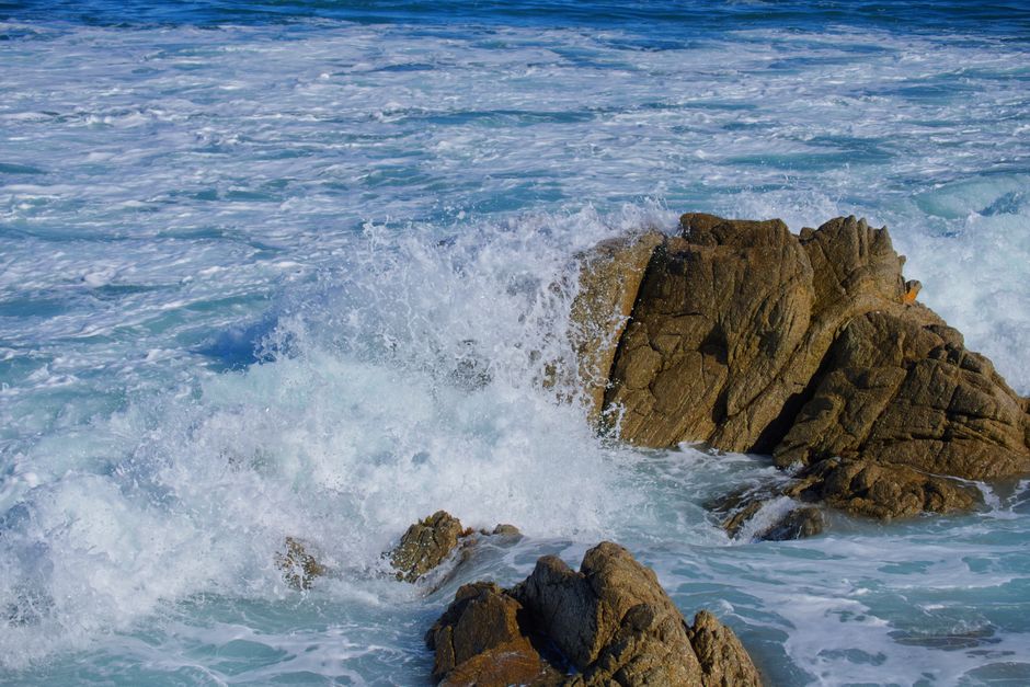
A Beach Hazards Statement has been issued for the northern Monterey Bay coastline, warning of significant wave activity expected to persist until early Wednesday morning. Surf heights of up to 15 feet are anticipated, with a minimum of 12 feet in many areas. This presents a serious risk to beachgoers, swimmers, surfers, and anyone venturing near the shoreline. Local authorities are urging extreme caution and advising the public to stay out of the water and well away from the surf zone. The National Weather Service (NWS) has been monitoring a developing weather system offshore that is generating these elevated surf conditions. The combination of strong onshore winds and a persistent swell from the west-northwest is contributing to the dangerous surf.
The specific areas impacted by this Beach Hazards Statement include the coastlines of Santa Cruz County and the northernmost portions of Monterey County. This encompasses popular beaches such as Santa Cruz Main Beach, Cowell Beach, Natural Bridges State Beach, Capitola Beach, and the beaches along the Monterey Peninsula, including Lovers Point Park and Pacific Grove. It is crucial for individuals planning to visit these areas to understand the heightened risks associated with these conditions. The large waves are not only a threat to swimmers and waders but also to those who might be observing the surf from the shoreline. Sneaker waves, characterized by their sudden and unpredictable nature, can surge far up the beach, catching unsuspecting individuals off guard and posing a severe drowning risk.
The NWS forecast indicates that the dangerous surf will begin to build today and is expected to reach its peak intensity overnight tonight and into Tuesday. While some minor decrease in wave height may be observed by early Wednesday morning, the hazard is expected to remain elevated for a considerable period. The sustained duration of these high surf conditions amplifies the danger, as the powerful surf can also contribute to increased coastal erosion and structural damage to piers and other coastal infrastructure. Mariners and boaters are also advised to exercise extreme caution. Even in sheltered harbors, the surge from these large waves can create dangerous conditions. Small craft should remain in port, and larger vessels should ensure they have adequate mooring and are prepared for potential impacts from wave action.
For those who are not experienced surfers, it is strongly recommended to avoid any water activities altogether. Even experienced surfers should exercise extreme caution and only enter the water if they are highly skilled and familiar with the local break, and even then, under significantly reduced wave conditions. The force of waves in the 10 to 15-foot range can easily overpower even the strongest swimmers and can cause serious injury from being tossed around or slammed against submerged objects. Lifeguards, where present, will likely be enforcing strict closures of the water. It is imperative to heed all posted signage and instructions from lifeguards and emergency personnel. Their primary concern is public safety, and their directives are based on expert assessments of the prevailing hazards.
The NWS has outlined specific dangers associated with this type of surf event. These include:
- Strong Rip Currents: Large waves often generate powerful and unpredictable rip currents. These currents can pull swimmers away from shore with surprising speed, even in seemingly calm areas between waves. Knowing how to escape a rip current (swim parallel to the shore until out of the current, then swim back to shore) is essential, but avoiding them altogether is the safest strategy during these advisories.
- Large Waves and Powerful Surf: The sheer force of 10 to 15-foot waves can be overwhelming. They can easily drag individuals under, cause them to hit the seabed or submerged objects, and lead to severe physical trauma.
- Sneaker Waves: As mentioned, these sudden, rogue waves can surge much further inland than anticipated. They can sweep people off rocks, piers, and even sandy beaches, leading to drowning or severe injury.
- Debris in the Water: High surf can stir up significant amounts of sand, kelp, and other debris, making visibility poor and increasing the risk of collisions or entanglement.
- Coastal Erosion: The sustained powerful wave action can accelerate coastal erosion, potentially undermining dunes, trails, and even structures located near the shoreline.
Authorities are particularly concerned about the upcoming weekend and the potential for people to disregard the warnings due to recreational desires. The beauty of the Monterey Bay coastline can be deceptive, and the danger posed by these elevated surf conditions is very real. Parents should ensure their children are kept at a safe distance from the water and are closely supervised at all times. The temptation to watch the large waves from exposed areas like jetties or rocky outcrops should be resisted. These are some of the most dangerous places to be during high surf events.
For travelers planning trips to the coast, it is advisable to check local weather forecasts and surf reports before departing and upon arrival. The NWS website and local news outlets will provide the most up-to-date information on the evolving surf conditions. If you are considering visiting the coast for its scenic beauty, ensure you do so from a safe vantage point well away from the surf line. Many coastal parks and overlooks offer stunning views without putting yourself in harm’s way.
In summary, the Beach Hazards Statement for northern Monterey Bay signals a period of significant danger along the coastline. The expected waves of up to 15 feet, persisting until early Wednesday morning, necessitate extreme caution. Public safety officials strongly advise against entering the water for any recreational purpose and urge everyone to remain a safe distance from the surf zone. Understanding the risks, heeding warnings, and prioritizing safety are paramount during this hazardous surf event. The NWS will continue to monitor the situation and issue updates as necessary. Mariners and boaters should also exercise extreme caution and consider postponing non-essential trips.
The duration of this elevated surf threat is a key concern. While the peak may pass by Wednesday morning, conditions are unlikely to return to normal immediately. Coastal residents and visitors should remain vigilant throughout the week. The dynamic nature of ocean conditions means that even slight shifts in wind or swell can impact the severity of the surf. Therefore, continuous monitoring of official advisories is recommended. The economic impact on local businesses that rely on beach tourism is also a consideration, but the immediate priority is unequivocally the preservation of life and limb. Visitors are encouraged to explore alternative attractions that do not involve direct interaction with the ocean during this period.


